Mountain Rescue Call Out
After 10 years of providing DofE expeditions we had our first mountain rescue call out in July this year (2017). Obviously after such an event we conducted a review of the incident to see if any changes to our procedures or advice to staff should be made. We had 2 Mountain Leader (ML) qualified staff and 2 groups out on the expedition that ran into trouble and to their credit they performed well. Lupine always have a minimum of one suitably qualified member of staff per DofE group on practice expeditions and on all expeditions in remote areas. When things are going well it sometimes seems like an overkill (especially with the advent of affordable tracking) but the fact is that when things go wrong you need people on the ground. Additionally, while not the case with this incident, when things go wrong they tend to go wrong for a reason that may affect other groups (poor weather, poor training, poor kit, limited hours of day light etc.). So if things are going to go wrong with one group there is an increased risk of things going wrong with multiple groups at the same time. We generated a more detailed, procedure specific report for all our freelancers but I thought I would write something here as it may be of use to others.
What happened
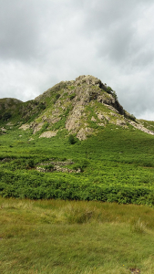
As stated above we had 2 groups out (one group of boys and one groups of girls) and two instructors on a practice expedition in The Lake District. We had conducted a day of acclimatisation with the groups and the two groups were to start their practice expedition being remotely supervised as our staff assessed that they were sufficiently competent and thus were ready for remote supervision. The groups were starting from Coniston and due to go north over Furness Fells before dropping down into Tilberthwaite and taking a fairly low level route round to Great Langdale (via Little Langdale and Elterwater). The boys had a late start and the ML with that group checked them up the copper mines valley and onto the fell before heading back to his vehicle and going round to Tilberthwaite. From there his intention was to climb the hill and shadow them across the top and down the Tilberthwaite valley.
At about noon we received a call in the office from some accompanying school staff to let us know that one of the boys had sustained a lower leg injury (a sprain or strain rather than a break) and that they were still on the tops. As the girls group were already over the top and on a low level route by now, both members of staff worked together to try and find the boys. After an hour or so they had re-traced the complete route and had not found them. The group were obviously both injured and off route. The ML’s then reported in to the office to update us on this turn of events. We took the decision at this point to notify mountain rescue even though it was still only 2 pm in early July. Calling Mountain Rescue can take a lot of time so getting all that information over early can help and they can then make the decision as to whether to wait a bit or to start a search. They took the decision to start assembling a team.
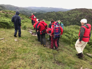
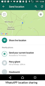
The ML’s who were already on the top decided on the next areas that they should search and started putting their plan into action. The boys at this point managed to send their location via WhatsApp to one of the teachers. The teachers then sent that link to us in the office and we converted it from latitude and longitude location into a UK grid reference and updated our staff and the mountain rescue team control. At this point our ML’s were about 500m away and heading in their direction so found them in about 15 minutes. Our ML’s then updated the mountain rescue team with a slightly more accurate grid reference and waited for help. Upon arrival the Mountain Rescue team decided that it was a stretcher off job so all the kit was left on the tops and the casualty was taken down to the base before going off to hospital for a check-up.
In the meantime we in the office contacted other staff that we had out in the Lakes whose duties had finished for the day and asked them to help by locating the girls group and ensuring that they were OK. The other group were located, a well-being check was performed and they continued on their way to their campsite where they met with their supervisor and some school staff.
Learning points
As stated above our ML’s did very well, our procedures were followed and were found to be robust.
1) Calling the office early. Office support can offer clear detached thinking that isn’t so easy when out searching for a group yourself. We were also able to arrange extra support for the girl’s group. As well as this we were able to be a point of contact for the accompanying teachers. Calling mountain rescue can feel like a bit step. Having the support of a director in the office instructing staff on the ground that that is what they should do probably reduced some of the stress in doing so.
2) Calling Mountain Rescue early. Mountain rescue teams can take time to assembly and deploy in non-life threatening situations. By calling them early they were able to assess the situation and decide whether they could deploy early. No one wants to be searching for a group in the dark and a call out just 3 hours later if the group were still not found could have resulted in this.
3) Our staff contact information. The first our staff heard that the group were lost was when we were called by the school staff. We have changed our procedures to ensure that groups know to call us first. We are also instructing our staff to write their number on the groups map as well as route card rather than our previous procedure which was on the route card and a credit card sized piece of card. We feel that the map is more readily available than a small piece of card.
4) Phone battery power. This incident resulted in a lot of mobile phone use. One leader’s phone died during the event. Modern smart phones do not hold a charge for a long time but they are also very useful to have for access to some of the apps. We now recommend that all staff carry a fully charged phone (like the Nokia 100) as an emergency phone to save their smart phone charge.
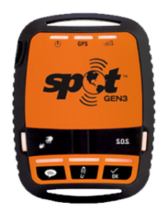
5) Trackers. We have a number of trackers that we deploy on some (but not all expeditions). They are becoming cheaper all the time and we expect they will become a standard piece of kit in time. There are issues with giving groups trackers and so we don’t routinely do so but if they had one it would have reduced the time taken to find them. At Lupine we have put lot of thought into tracking groups and how to do so without negatively impacting on the expedition experience and reducing safety (as mentioned above we would not reduce our staffing ratio just because we can track a group). Another blog post maybe.
6) Familiarisation with mobile phone apps. Do you have an app that can translate Latitude and Longitude into a grid reference on your phone? They are free to download. Did you know you can type Latitude and Longitude co-ordinates into Google Maps and OS maps (and probably other mapping apps) and it will drop a pin at the location. Most groups will have smartphones on them. You could advise that participants download OS locate during their training to help them locate themselves in an emergency. We also advise that staff familiarise themselves with getting a location from a participant’s smart phone in other ways.
a) Whatsapp. – quick , easy , simple, not much data needed, many participants have Whatsapp installed
Send a message to group asking them to carry out the following
i) Tap the paperclip (android) or + (on iPhone) where you normally type a message. ii) Tap ‘location’ iii) Tap ‘send current location.’
b) iPhones – no data needed, information is sent by text message
iPhones have a compass app built in that shows latitude and longitude.
c) Android – No data needed. Open the Google Maps app. Touch and hold where you are (shown by the blue dot) and it will give latitude and longitude co-ordinates in the search box at the top. This can then be copied and texted.
d) Website – medium amount of data needed
There are a number of websites such as www.whereamirightnow.com with easy instructions on how to share your current location.
e) Sarloc for DofE. Sarloc is a system that many mountain rescue teams have used in the past. You as the leader need to register via this Facebook page. https://www.facebook.com/sarlocDofE/ you then get a text message with a link that you can send the group. They then tap a link and if they have a tiny bit of data capacity on their phone and their GPS is on then it will send their Grid reference to a server that you can go to to see.
We have updated our guide to remote supervision and searches booklet to reflect some of these points.
We are of course indebted to the Coniston Mountain Rescue team and have made a donation to their funds, if you would like to donate to them as well you can do so here https://conistonmrt.org.uk/donate/
